


The Atlantic Ocean is the second largest of the world’s five ocean basins (after the Pacific Ocean, but larger than the Indian Ocean, Southern Ocean, and Arctic Ocean). The Kiel Canal (Germany), Oresund (Denmark-Sweden), Bosporus (Turkey), Strait of Gibraltar (Morocco-Spain), and the Saint Lawrence Seaway (Canada-US) are important strategic access waterways. The decision by the International Hydrographic Organization in the spring of 2000 to delimit a fifth world ocean basin, the Southern Ocean, removed the portion of the Atlantic Ocean south of 60 degrees south latitude. For convenience and because of its immense size, the Atlantic Ocean is often divided at the Equator and designated as the North Atlantic Ocean and the South Atlantic Ocean.TipVisit the Definitions and Notes page to view a description of each topic.Definitions and Notes
Geography
Location
body of water between Africa, Europe, the Arctic Ocean, the Americas, and the Southern Ocean
Geographic coordinates
0 00 N, 25 00 W
Map references
Area
total : 85.133 million sq km
note: includes Baffin Bay, Baltic Sea, Black Sea, Caribbean Sea, Davis Strait, Denmark Strait, part of the Drake Passage, Hudson Bay, Hudson Strait, Gulf of America, Labrador Sea, Mediterranean Sea, North Sea, almost all of the Scotia Sea, and other tributary water bodies
Area – comparative
about 7.5 times the size of the US
Coastline
111,866 km
Climate
tropical cyclones (hurricanes) develop off the coast of Africa near Cabo Verde and move westward into the Caribbean Sea; hurricanes can occur from May to December but are most frequent from August to November
Ocean volume
ocean volume: 310,410,900 cu km
percent of World Ocean total volume: 23.3%
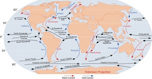
Major ocean currents
clockwise North Atlantic Gyre consists of the northward flowing, warm Gulf Stream in the west, the eastward flowing North Atlantic Current in the north, the southward flowing cold Canary Current in the east, and the westward flowing North Equatorial Current in the south; the counterclockwise South Atlantic Gyre composed of the southward flowing warm Brazil Current in the west, the eastward flowing South Atlantic Current in the south, the northward flowing cold Benguela Current in the east, and the westward flowing South Equatorial Current in the north
Major World Ocean Currents:
Bathymetry
continental shelf: the passive margins of the Atlantic Ocean provide for wide continental shelves in North America, Northwest Europe, and the southern coast of South America
the following are examples of features on the continental shelf of the Atlantic Ocean:
Blake Plateau (Figure 5)
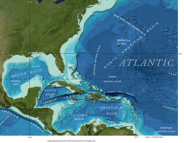
Celtic Shelf (Figure 2)
Dogger Bank (Figure 2)
Flemish Cap (Figure 2)
Falkland Plateau (Figure 3)
Grand Banks of Newfoundland (Figure 2)
Great Bahama Bank (Figure 5)
Little Bahama Bank (Figure 5)
Tunisian Plateau (Figure 4)
Yucatán Shelf (Figure 5)
continental slope: the following are examples of features on the continental slope of the Atlantic Ocean:
Amazon Cone (Figure 3)
Congo Fan (Figure 3)
Hudson Canyon (Figure 5)
Mississippi Fan (Figure 5)
abyssal plains: the following are examples of features on the abyssal plains of the Atlantic Ocean:
Angola Basin (Figure 3)
Agulhas Basin (Figure 3)
Argentine Basin (Figure 3)
Brazil Basin (Figure 3)
Canary Basin (Figure 2)
Cape Basin (Figure 3)
Colombia Basin (Figure 2)
Labrador Basin (Figure 2)
Mexico Basin (Figure 2)
Newfoundland Basin (Figure 2)
North American Basin (Figure 2)
Venezuela Basin (Figure 2)
West European Basin (Figure 2)
mid-ocean ridge: the Charlie-Gibbs Fracture Zone displaces the mid-ocean ridge 350 km to the west, separating the Mid-Atlantic Ridge from the Reykjanes Ridge; the Romanche Fracture Zone, located near the equator, offsets the Mid-Atlantic Ridge 900 km and is considered the dividing line between the North and South Atlantic Oceans
the following are examples of mid-ocean ridges on the floor of the Atlantic Ocean:
East Mediterranean Ridge (Figure 4)
Mid-Atlantic Ridge (Figures 2, 3)
Reykjanes Ridge (Figure 2)
undersea terrain features: the following are examples of undersea terrain features on the floor of the Atlantic Ocean:
Bermuda Rise (Figure 2)
Cape Verde Plateau (Figure 2)
New England Seamounts (Figure 2)
Rio Grande Plateau (Figure 3)
Rockall Plateau (Figure 2)
ocean trenches: the following are examples of ocean trenches on the floor of the Atlantic Ocean:
Cayman Trench (Caribbean Sea) (Figure 2)
Hellenic Trench (Mediterranean Sea) (Figure 4)
Puerto Rico Trench (Figure 2) – deepest point in the Atlantic
South Sandwich Trench (South Atlantic) (Figure 3)
atolls: Rocas Atoll (Brazil) is the only atoll in the South Atlantic
Figure 1. Profile of the sea floor:
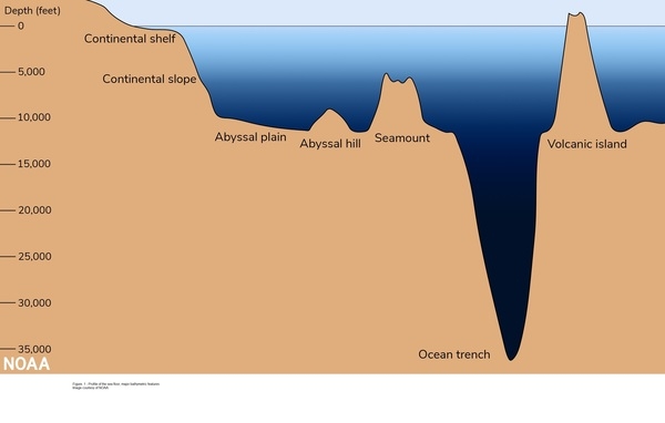
Figure 2. North Atlantic:
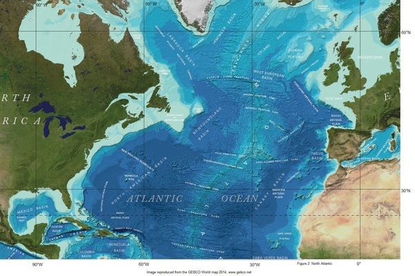
Figure 3: South Atlantic sea floor:
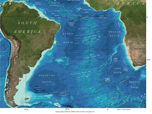
Figure 4: Mediterranean Sea:
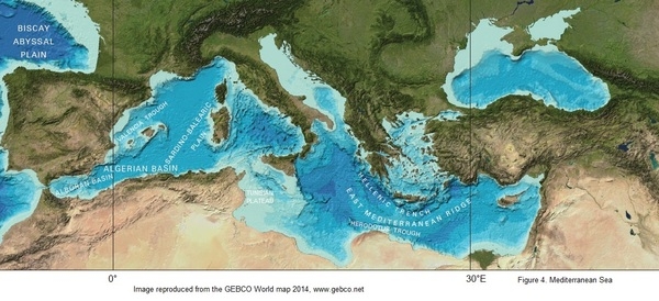
Figure 5. Caribbean Basin and Western Atlantic:
Elevation
highest point: sea level
lowest point: Puerto Rico Trench -8,605 m
mean depth: -3,646 m
ocean zones: the ocean is divided into three zones based on depth and light level; sunlight entering the water may travel about 1,000 m into the oceans under the right conditions, but there is rarely any significant light below 200 m
euphotic zone: the upper 200 m (656 ft) is also called “sunlight” zone; only a small amount of light penetrates beyond this depth
dysphotic zone: between 200 m (656 ft) and 1,000 m (3,280 ft), and also called the twilight zone; the intensity of light rapidly dissipates as depth increases, and photosynthesis is no longer possible
aphotic zone: below 1,000 m (3,280 ft) and also called the midnight zone; sunlight does not penetrate to these depths
Distance Sunlight Travels in the Ocean:

Natural resources
oil and gas fields, fish, marine mammals (seals and whales), sand and gravel aggregates, placer deposits, polymetallic nodules, precious stones
Natural hazards
icebergs common in Davis Strait, Denmark Strait, and the northwestern Atlantic Ocean from February to August and have been spotted as far south as Bermuda and the Madeira Islands; ships subject to superstructure icing in extreme northern Atlantic from October to May; persistent fog can be a maritime hazard from May to September; hurricanes (May to December)
Geography – note
major chokepoints include the Dardanelles, Strait of Gibraltar, access to the Panama and Suez Canals; strategic straits include the Strait of Dover, Straits of Florida, Mona Passage, The Sound (Oresund), and Windward Passage; the equator divides the Atlantic Ocean into the North Atlantic Ocean and South Atlantic Ocean
Environment
Environmental issues
endangered marine species; fishery issues (over-fishing, unregulated bottom trawling, drift-net fishing, discards, catch of non-target species); pollution (maritime transport, discharges, offshore drilling, oil spills, improperly disposed waste); municipal sludge pollution off eastern US, southern Brazil, and eastern Argentina; oil pollution in Caribbean Sea, Gulf of America, Lake Maracaibo, Mediterranean Sea, and North Sea; industrial waste and municipal sewage pollution in Baltic Sea, North Sea, and Mediterranean Sea
Climate
tropical cyclones (hurricanes) develop off the coast of Africa near Cabo Verde and move westward into the Caribbean Sea; hurricanes can occur from May to December but are most frequent from August to November
Marine fisheries
the Atlantic Ocean fisheries are the second most important in the world accounting for 25.8%, or 20,300,000 mt, of the global catch in 2020; of the seven regions delineated by the Food and Agriculture Organization in the Atlantic basin, the most important include the following:
Northeast Atlantic region (Region 27) is the fourth most important in the world, producing 10.5% of the global catch or 8,310,000 mt in 2020; the region encompasses the waters north of 36º North latitude and east of 40º West longitude, with the major producers including Norway (3,528,240 mt), Russia (1,044,153 mt), Iceland (933,019 mt), UK (823,669 mt), and Denmark (641,927 mt); the region includes the historically important fishing grounds of the North Sea, the Baltic Sea, and the Atlantic waters around Greenland, Iceland, and the British Isles; the principal catches include Atlantic cod, haddock, saithe (pollock), blue whiting, herring, and mackerel
Eastern Central Atlantic region (Region 34) is the second most important Atlantic fishery, and seventh largest in the world, producing more than 6.3% of the global catch or 4,950,000 mt in 2020; the region encompasses the waters between 36º North and 6º South latitude and east of 40º West longitude off the west coast of Africa, with the major producers including Morocco (1,419,872 mt), Mauritania (705,850 mt), Senegal (472,571 mt), Nigeria (451,768 mt), Ghana (303,001 mt), Cameroon (265,969 mt), and Sierra Leone (200,000 mt); the principal catches include pilchard, sardinellas, shad, and mackerel
Northwest Atlantic region (Region 21) is the fourth most important Atlantic fishery and eleventh in the world producing 1.9% of the global catch and 1,540,000 mt in 2020; it encompasses the waters north of 35º North latitude and west of 42º West longitude, including major fishing grounds over North America’s continental shelf (the Grand Banks, Georges Bank, Flemish Cap, and Baffin Bay); the major producers include the US (927,777 mt), Canada (615,651 mt), and Greenland (179,990 mt); the principal catches include sea scallops, prawns, lobster, herring, and menhaden
Mediterranean and Black Sea region (Region 37) is a minor fishing region representing 1.5% or 1,190,000 mt of the world’s total capture in 2020; the region encompasses all waters east of the Strait of Gibraltar, with the major producers including Turkey (686,650 mt), Italy (281,212 mt), Tunisia (129,325 mt), Spain (119,759 mt), and Russia (72,279 mt); the principal catches include European anchovy, European pilchard, gobies, and clams
Regional fisheries bodies: Commission for the Conservation of Southern Bluefin Tuna, Fishery Committee for the Eastern Central Atlantic, Fisheries Committee for the West Central Gulf of Guinea, General Fisheries Commission for the Mediterranean, International Commission for the Conservation of Atlantic Tunas, International Council for the Exploration of the Seas, Northwest Atlantic Fisheries Organization, North Atlantic Salmon Conservation Organization, North East Atlantic Fisheries Commission, Southeast Atlantic Fisheries Organization, Western Central Atlantic Fishery CommissionFAO map of world fishing regions; used with permission.
Government
Country name
etymology: name derives from the ancient Greek description of the waters beyond the Strait of Gibraltar, Atlantis thalassa, meaning “Sea of Atlas”
Transportation
Transportation – note
Kiel Canal and Saint Lawrence Seaway are two important waterways; significant domestic commercial and recreational use of Intracoastal Waterway on central and south Atlantic seaboard and Gulf of America coast of US


