


The Pacific Ocean is the largest of the world’s five ocean basins (followed by the Atlantic Ocean, Indian Ocean, Southern Ocean, and Arctic Ocean). Strategically important access waterways include the La Perouse, Tsugaru, Tsushima, Taiwan, Singapore, and Torres Straits. The International Hydrographic Organization decision in 2000 to delimit a fifth world ocean basin, the Southern Ocean, removed the portion of the Pacific Ocean south of 60 degrees south. For convenience and because of its immense size, the Pacific Ocean is often divided at the Equator and designated as the North Pacific Ocean and the South Pacific Ocean.TipVisit the Definitions and Notes page to view a description of each topic.Definitions and Notes
Geography
Location
body of water between the Southern Ocean, Asia, Australia, and the Western Hemisphere
Geographic coordinates
0 00 N, 160 00 W
Area
total : 168.723 million sq km
note: includes Arafura Sea, Bali Sea, Banda Sea, Bering Sea, Bering Strait, Celebes Sea, Coral Sea, East China Sea, Flores Sea, Gulf of Alaska, Gulf of Thailand, Gulf of Tonkin, Java Sea, Philippine Sea, Sea of Japan, Sea of Okhotsk, Solomon Sea, South China Sea, Sulu Sea, Tasman Sea, and other tributary water bodies
Area – comparative
about 15 times the size of the US; covers about 28% of the global surface; almost equal to the total land area of the world
Coastline
135,663 km
Climate
planetary air pressure systems and resultant wind patterns exhibit remarkable uniformity in the south and east; trade winds and westerly winds are well-developed patterns, modified by seasonal fluctuations; tropical cyclones (hurricanes) may form south of Mexico from June to October and affect Mexico and Central America; continental influences cause climatic uniformity to be much less pronounced in the eastern and western regions at the same latitude in the North Pacific Ocean; the western Pacific is monsoonal – a rainy season occurs during the summer months, when moisture-laden winds blow from the ocean over the land, and a dry season during the winter months, when dry winds blow from the Asian landmass back to the ocean; tropical cyclones (typhoons) may strike southeast and east Asia from May to December
Ocean volume
ocean volume: 669.88 million cu km
percent of World Ocean total volume: 50.1%
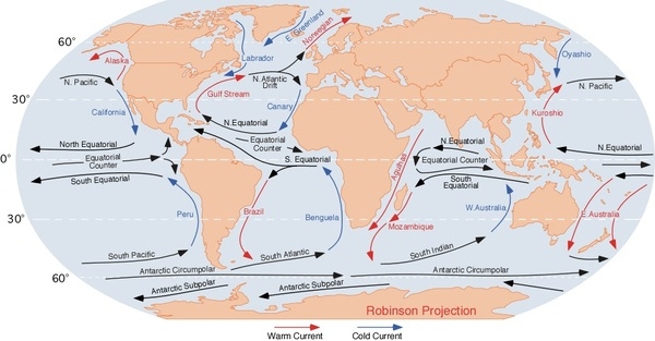
Major ocean currents
the clockwise North Pacific Gyre formed by the warm northward flowing Kuroshio Current in the west, the eastward flowing North Pacific Current in the north, the southward flowing cold California Current in the east, and the westward flowing North Equatorial Current in the south; the counterclockwise South Pacific Gyre composed of the southward flowing warm East Australian Current in the west, the eastward flowing South Pacific Current in the south, the northward flowing cold Peru (Humbolt) Current in the east, and the westward flowing South Equatorial Current in the north
Major World Ocean Currents:
Bathymetry
continental shelf: the following are examples of features on the continental shelf of the Pacific Ocean:
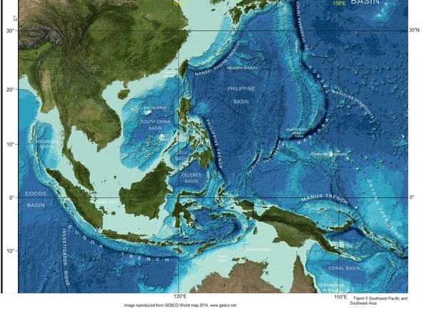
Arafura Shelf (Figure 5)
Sahul Shelf (Figure 5)
Sunda Shelf (Figure 5)
Taiwan Banks (Figure 5)
continental slope: the following are examples of features on the continental slope of the Pacific Ocean:
Pribilof Canyon (Figure 2)
Zhemchug Canyon (Figure 2; deepest submarine canyon)
abyssal plains: the following are examples of features on the abyssal plains of the Pacific Ocean:
Aleutian Basin (Figure 2)
Central Pacific Basin (Figure 2)
Northeast Pacific Basin (Figure 2)
Northwest Pacific Basin (Figure 2)
Philippine Basin (Figure 4)
Southwest Pacific Basin (Figure 4)
Tasman Basin (Figure 4)
mid-ocean ridge: the following are examples of mid-ocean ridges on the floor of the Pacific Ocean:
East Pacific Rise (Figure 3)
Pacific-Antarctic Ridge (Figure 3)
undersea terrain features: the following are examples of undersea terrain features on the floor of the Pacific Ocean:
Caroline Seamounts (Figure 5)
East Mariana Ridge (Figure 4)
Emperor Seamount Chain (Figure 2)
Hawaiian Ridge (Figure 2)
Lord Howe Seamount Chain (Figure 4)
Louisville Ridge (Figure 4)
Kapingamarangi (Ontong-Java) Rise (Figure 5; largest submarine plateau)
Macclesfield Bank (Figure 5)
Marshall Seamounts (Figure 2)
Magellan Seamounts (Figure 2)
Mid-Pacific Seamounts (Figure 2)
Reed Tablemount (Figure 5)
Shatsky Rise (Figure 2; third-largest submarine plateau)
Tonga-Kermadec Ridge (Figure 4)
ocean trenches: the following are examples of ocean trenches on the floor of the Pacific Ocean:
Aleutian Trench (Figure 2)
Chile Trench (Figure 3)
Izu-Ogasawara Trench (Figure 2)
Japan Trench (Figure 2)
Kermadec Trench (Figures 3, 4)
Kuril-Kamchatka Trench (Figure 2)
Manus Trench (Figure 4)
Mariana Trench (Figures 2, 4; deepest ocean trench)
Middle America Trench (Figure 3)
Nansei-Shoto Trench (Figure 5)
Palau Trench (Figures 2, 4)
Philippine Trench (Figure 4)
Peru-Chile Trench (Figure 3)
South New Hebrides Trench (Figure 4)
Tonga Trench (Figures 3, 4)
Yap Trench (Figures 2, 4)
atolls: the following are examples of atolls in the Pacific Ocean, and because they are also countries or territories, they have entries in The World Factbook with additional information:
Federated States of Micronesia
French Polynesia
Kiribati
Marshall Islands
Midway Island
Tonga
Tuvalu
Vanuatu
Wake Island
Figure 1. Profile of the sea floor:
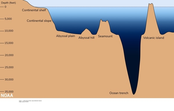
Figure 2: North Pacific sea floor:

Figure 3: Southeast Pacific sea floor:
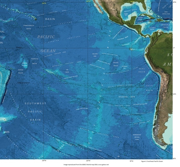
Figure 4: Southwest Pacific sea floor:
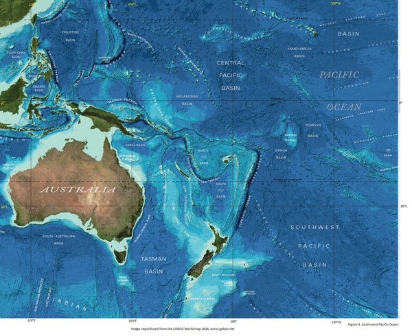
Figure 5. Southwest Pacific Ocean and Southeast Asia:
Elevation
highest point: sea level
lowest point: Challenger Deep in the Mariana Trench -10,924 m
mean depth: -4,080 m
ocean zones: the ocean is divided into three zones based on depth and light level; sunlight entering the water may travel about 1,000 m into the oceans under the right conditions, but there is rarely any significant light below 200 m
euphotic zone: the upper 200 m (656 ft) is also called “sunlight” zone; only a small amount of light penetrates beyond this depth
dysphotic zone: between 200 m (656 ft) and 1,000 m (3,280 ft), and also called the twilight zone; the intensity of light rapidly dissipates as depth increases, and photosynthesis is no longer possible
aphotic zone: below 1,000 m (3,280 ft) and also called the midnight zone; sunlight does not penetrate to these depths
note: the Pacific Ocean is the deepest ocean basin
Distance Sunlight Travels in the Ocean:

Natural resources
oil and gas fields, polymetallic nodules, sand and gravel aggregates, placer deposits, fish
Natural hazards
surrounded by a zone of violent volcanic and earthquake activity sometimes referred to as the “Pacific Ring of Fire”; up to 90% of the world’s earthquakes and some 75% of the world’s volcanoes occur within the Ring of Fire; 80% of tsunamis, caused by volcanic or seismic events, occur within the “Pacific Ring of Fire”; subject to tropical cyclones (typhoons) in southeast and east Asia from May to December (most frequent from July to October); tropical cyclones (hurricanes) may form south of Mexico and strike Central America and Mexico from June to October (most common in August and September); cyclical El Niño/La Niña phenomenon occurs in the equatorial Pacific, influencing weather in the Western Hemisphere and the western Pacific; ships subject to superstructure icing in extreme north from October to May; persistent fog in the northern Pacific can be a maritime hazard from June to December
Geography – note
the major chokepoints are the Bering Strait, Panama Canal, Luzon Strait, and the Singapore Strait; the equator divides the Pacific Ocean into the North Pacific Ocean and the South Pacific Ocean; dotted with low coral islands and rugged volcanic islands in the southwestern Pacific Ocean; much of the Pacific Ocean’s rim lies along the Ring of Fire, which is a belt that contains about 75% of the world’s volcanoes and up to 90% of the world’s earthquakes; the Pacific Ocean is the deepest ocean basin, averaging 4,000 m (13,123 ft) in depth
Environment
Environmental issues
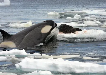
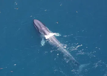
pollution from sources such as sewage, nutrient runoff from agriculture, plastic pollution, and toxic waste; habitat destruction; overfishing; sea level-rise and ocean acidification; endangered marine species include the dugong, sea lion, sea otter, seals, turtles, and whales; oil pollution in Philippine Sea and South China Sea
Climate
planetary air pressure systems and resultant wind patterns exhibit remarkable uniformity in the south and east; trade winds and westerly winds are well-developed patterns, modified by seasonal fluctuations; tropical cyclones (hurricanes) may form south of Mexico from June to October and affect Mexico and Central America; continental influences cause climatic uniformity to be much less pronounced in the eastern and western regions at the same latitude in the North Pacific Ocean; the western Pacific is monsoonal – a rainy season occurs during the summer months, when moisture-laden winds blow from the ocean over the land, and a dry season during the winter months, when dry winds blow from the Asian landmass back to the ocean; tropical cyclones (typhoons) may strike southeast and east Asia from May to December
Marine fisheries
the Pacific Ocean fisheries are the most important in the world, accounting for 58.1%, or 45,800,000 mt, of the global marine capture in 2020; of the six regions delineated by the Food and Agriculture Organization in the Pacific Ocean, the following are the most important:
Northwest Pacific region (Region 61) is the world’s most important fishery, producing 24.3% of the global catch or 19,150,000 mt in 2020; it encompasses the waters north of 20º north latitude and west of 175º west longitude, with the major producers including China (29,080726 mt), Japan (3,417,871 mt), South Korea (1,403,892 mt), and Taiwan (487,739 mt); the principal catches include Alaska pollock, Japanese anchovy, chub mackerel, and scads
Western Central Pacific region (Region 71) is the world’s second most important fishing region producing 16.8%, or 13,260,000 mt, of the global catch in 2020; tuna is the most important species in this region; the region includes the waters between 20º North and 25º South latitude and west of 175º West longitude with the major producers including Indonesia (6,907,932 mt), Vietnam (4,571,497 mt), Philippines (2,416,879 mt), Thailand (1,509,574 mt), and Malaysia (692,553 mt); the principal catches include skipjack and yellowfin tuna, sardinellas, and cephalopods
Southeast Pacific region (Region 87) is the third largest fishery in the world, producing 10.7%, or 8,400,000 mt, of the global catch in 2020; this region includes the nutrient-rich waters off the west coast of South America between 5º North and 60º South latitude and east of 120º West longitude, with the major producers including Peru (4,888,730 mt), Chile (3,298,795 mt), and Ecuador (1,186,249 mt); the principal catches include Peruvian anchovy (68.5% of the catch), jumbo flying squid, and Chilean jack mackerelPacific Northeast region (Region 67) is the eighth largest fishery in the world, producing 3.6% of the global catch or 2,860,000 mt in 2020; this region encompasses the waters north of 40º North latitude and east of 175º West longitude, including the Gulf of Alaska and Bering Sea, with the major producers including the US (3,009,568 mt), Canada (276,677 mt), and Russia (6,908 mt); the principal catches include Alaska pollock, Pacific cod, and North Pacific hake
Regional fisheries bodies: Commission for the Conservation of Southern Bluefin Tuna, Inter-American Tropical Tuna Commission, International Council for the Exploration of the Seas, North Pacific Anadromous Fish Commission, North Pacific Fisheries Commission, South Pacific Regional Fisheries Management Organization, Southeast Asian Fisheries Development Center, Western and Central Pacific Fisheries CommissionFAO map of world fishing regions; used with permission.
Government
Country name
etymology: named by Portuguese explorer Ferdinand MAGELLAN while circumnavigating the world in 1520; he called it “Mar Pacifico,” which means “peaceful sea” in both Portuguese and Spanish, because he encountered no storms during the crossing


